Latest News: Read more


Yellow arrow with nameAllan King Way

Hampshire

71 km / 44 miles
A walk devised by the Hampshire Area Ramblers in memory of Allan King, one of their early members. The route links the old Roman strongholds of Portchester and Winchester.

From Porchester Castle the route heads west along the foreshore before turning north to cross the M27, and railway, to reach Fort Nelson and Nelson's Monument. Still meandering northwards the route passes through the villages of World's End and Soberton, where it turns west. crossing the River Meon, to reach the ruined Bishop's Palace at Bishop's Waltham. The line of the old Roman road from Porchester to Winchester is followed for a short distance before reaching Upham and Cheesefoot Head. The walk now heads to Ovington where it follows the Itchen Way and then the Nun's Walk into Winchester and its finish at the marker post next to the wall of Wolvesley Castle.

November 2025: right of way problem reported at Hole Farm (Barn), near Hoe Gate (SU 631140). Permissive paths may be available as alternatives.


Details:

Waymark: Yellow arrow with name
Path Type: Paths Marked on OS mapping
Waymark: Yellow arrow with name
Attributes: Paths marked on OS mapping
Average Gradients
Coastal
Downland/Wolds
River
Start: SU618058 - Portchester, Hampshire
Finish: SU484290 - Winchester, Hampshire
Web Sites: Allan King Way [YouTube video] Allan King Way Part 1 [blog] Allan King Way Part 2 [blog] Allan King Way Part 3 [blog] Allan King Way Part 4 [blog]

Publications, Badges and Certificates:

External download Eastleigh Ramblers - Alan King Way Hampshire  (Eastleigh Ramblers  - 2023 ) Download

Maps:

You can use the interactive controls to zoom in and out and to move around the map, or click on a path or a marker for more info.(interactive map help)

Show Connected Path Outlines
National Trails (England & Wales)
Paths Marked on OS mapping
Other Paths

Contains Ordnance Survey data © Crown copyright and database right 2016.
© OpenStreetMap contributors under Open Database Licence.
Rights of way data from selected Local Authorities.
Large scale digital mapping is provided by John Thorn.
At high zoom levels the route is indicative only.
Purchase Ordnance Survey Maps (path is named on OS maps):
OS Landranger 185, 196
OS Landranger Active 185, 196
OS Explorer 3, 29, 32
OS Explorer Active 3, 29, 32

Connected Paths:


Downloads:

Reminder: Material downloaded from this website is for personal or LDWA use only. Commercial use, reproduction, modification of all content is strictly prohibited without prior approval by the LDWA. Please Contact Us if you have any requests.

GPX Route File
Allan King Way GPX Exchange Format Route File
Last Updated 04/12/2024 23:13:56
Login to Download
(Members Only)
MemoryMap Route File
Allan King Way Memory Map Route File
Last Updated 04/12/2024 23:13:56
Login to Download
(Members Only)
Tracklogs Route File
Allen King Way Tracklogs Route file
Last Updated 04/12/2024 23:13:56
Login to Download
(Members Only)

Route Profile:

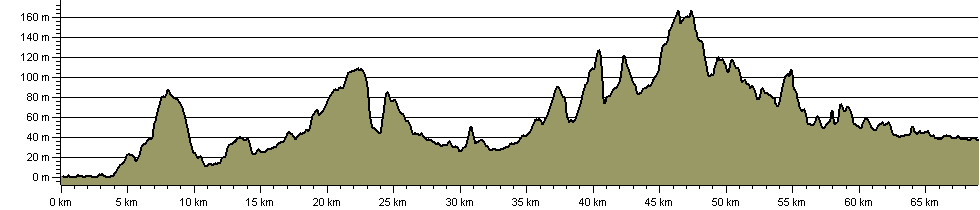
70.9 km (44.1 miles)
890 m (2,920 ft) ascent
168 m (551 ft)  maximum height

This website uses cookies

To comply with EU Directives we are informing you that our website uses cookies for services such as memberships and Google Analytics.

Your data is completely safe and we do not record any personally identifiable information.

Please click the button to acknowledge and approve our use of cookies during your visit.

Learn more about the Cookie Law