Latest News: Read more


Named discsVanguard Way

E Sussex, Gtr London, Kent, Surrey

106 km / 66 miles
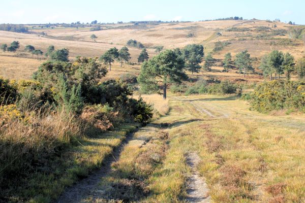
A route from the South London suburbs to the sea, it crosses the North Downs, Ashdown Forest and South Downs to finish along the Sussex Heritage Coast over Seaford Head to Newhaven.

This trail has its roots in the early '80s when a group of South London ramblers sought adventure down south. Colin Saunders, chair of the Vanguard Way Association, wrote: "The trail was created in 1981 by members of the Vanguard Rambling Club, which took its name from a train journey in 1965 when they had to sit on the floor of the 'guard's van', because no seats were available." (Source: mylondon.news)

A new route in the Edenbridge area has been developed due to the increase in traffic on lanes used by the original route: it is almost entirely on footpaths and has the added advantage that it will go closer to stations at Edenbridge with just one link, whereas previously there were two separate links. Less substantial route changes include new links with Warlingham, Haxted Mill, Gabriel's Fishery and Seaford Station, and an optional alternative route into Forest Row to avoid a footpath that is currently in a dreadful state. Route guides are available to download free from the Vanguard Way website below.

It connects with the Wandle Trail and the London Loop in Greater London and numerous other long distance paths including the North Downs, Greensand, Eden Valley and South Downs Ways.

The Wandle Trail (11 miles) provides a link to the Thames Path National Trail at Wandsworth, enabling a route from the Thames to the sea.

Comprehensive information about this path can be found on the official Vanguard Way website - below.


Details:

Waymark: Named discs
Path Type: Paths Marked on OS mapping
Waymark: Named discs
Attributes: Average Gradients
Coastal
Heath
Start: TQ328658 - East Croydon Railway Station, Gtr London
Finish: TQ449009 - Newhaven Harbour, E Sussex
User Group: Vanguard Way Association
Web Sites: Vanguard Way Pete's Trip Reports - Vanguard Way [blog]

Publications, Badges and Certificates:

Certificate Certificate for Vanguard Way  (Vanguards Rambling Club )
Badge Badge for Vanguard Way  (Vanguards Rambling Club )

Maps:

You can use the interactive controls to zoom in and out and to move around the map, or click on a path or a marker for more info.(interactive map help)

Show Connected Path Outlines
E Routes
National Trails (England & Wales)
Paths Marked on OS mapping
Other Paths

Show Accommodation
Hostel Accommodation

Contains Ordnance Survey data © Crown copyright and database right 2016.
© OpenStreetMap contributors under Open Database Licence.
Rights of way data from selected Local Authorities.
Large scale digital mapping is provided by John Thorn.
At high zoom levels the route is indicative only.
Purchase Ordnance Survey Maps (path is named on OS maps):
OS Landranger 176, 177, 187, 188, 198, 199
OS Landranger Active 176, 177, 187, 188, 198, 199
OS Explorer 11, 25, 135, 146, 147, 161
OS Explorer Active 11, 25, 135, 146, 147, 161

Accommodation within 5 km of this Path:


From
Path
Along
Path
Hostel Accommodation
5 km
106 km

Connected Paths:


Downloads:

Reminder: Material downloaded from this website is for personal or LDWA use only. Commercial use, reproduction, modification of all content is strictly prohibited without prior approval by the LDWA. Please Contact Us if you have any requests.
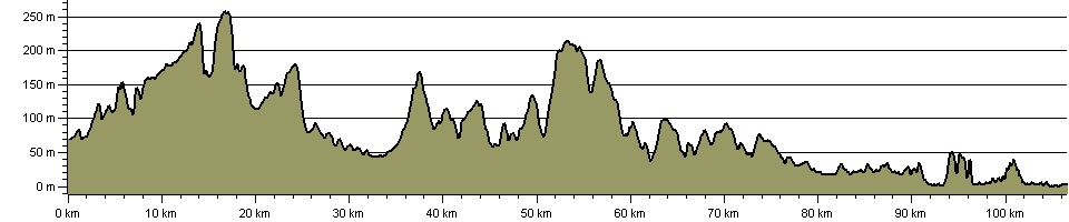

Route Profile:

106.5 km (66.2 miles)
1,859 m (6,099 ft) ascent
260 m (853 ft)  maximum height

This website uses cookies

To comply with EU Directives we are informing you that our website uses cookies for services such as memberships and Google Analytics.

Your data is completely safe and we do not record any personally identifiable information.

Please click the button to acknowledge and approve our use of cookies during your visit.

Learn more about the Cookie Law