


June Jamborees
Sunday June 30th. Holy Moel-y. 20 miles. Leader: Mike Bushby.
Noun. moel (plural moels) A hill having a rounded outline in its upper portion because the summit is protected from rapid denudation by a layer of soil and a growth of forest trees or grass, or by marshes of peat.
Exclamation. Holy Moely! That which shall be shouted with gusto upon ascending a moel.
Despite setting out at Loggerheads (Country Park), the group of nine were in good spirits and braced for a tough but rewarding day. The first few miles followed The Clwydian Way north along the River Alun in a pretty wooded valley then rising slightly to pass Devil's Gorge (9.30am was too early for climbers, it seemed) and onto Cilcain with its pristine toilets. On the map the paths across fields to join Offa's Dyke just south of Moel y Parc looked fairly innocuous but actually involved a number of short, sharp climbs that began to wear you out even before the proper hills. There were also dozens of stiles to negotiate. Fortunately the majority were sturdy metal ones but they must have contributed a couple of hundred feet to the day's ascent.
The bulk of our route, basically a roller-coastery backbone ridge of the Clwydian Range, had been visible to our left/west for most of the morning. Substantial hills, though not particularly daunting to look at from afar, you might think. However, we'd find out there was more to them than met the eye...
As we turned SSE onto Offa's Dyke Path for our first proper climb, we felt the force of a wind that would billow for the next few hours (and take one of our party by surprise at the pm break). This ascent of Penycloddiau was steady and may have lulled some into wondering what the 'Strenuous' label for the walk was all about. There was an interesting ancient mound at the summit, though sadly, it's not the right shaped peak to be a moel, so no Holy Moely! here.
After lunch in a relatively bluster-free dip, Moel Arthur was up next. This was a hard thrutch up to the site of an Iron Age hill fort and definitely worthy of a Holy Moely! The next moel (Llys y Coed) was no more than a few hundred metres away horizontally - there was just the matter of a severe valley in-between, and things weren't helped by getting onto a path that wasn't part of the recce. Besides gorse scraping shins it was as steep as you could get without needing ropes, and there was relief all round to reach level ground. I blamed Bob, who had been in front as we left the summit.
After another panting, sweaty effort to regain our height, we could finally enjoy the reward of striding out on the broad ridge. The views were fabulous: Snowdonia (in cloud, unfortunately), Great Orme and the North Wales Coast, masses of turbines that were probably working overtime in that wind, Liverpool and the Mersey Estuary, Lancashire's hills beyond.
There was one more ascent to reach Jubilee Tower sitting grandly atop Moel Famau, our high point at 1821'/555m. Holy Moely!! After the obligatory group pics, Dave amused us all by getting blown over from his seated position by a sudden gust of wind. We checked he wasn't hurt before laughing at him, of course.
From there it was pleasant walking on good paths and tracks, through a bit of forest and ending up at at Loggerheads once more, but all still getting on fine. Data was checked: well over a Ben Nevis of climbing. Just under 20 miles. (My map string was ok planning this one). 7 hours 40 minutes. "Made good time," someone said. "Had good time," I responded. A hard walk, but a cracker. Holy Moely!
Michael
Click here for Michael's pictures.
Sunday June 23rd. Ramsbottom Round. 20 miles. Leaders: Dave and Alma Walsh.
The promise of tea & cakes in the afternoon & a decent weather forecast combined to prompt 23 walkers to gather at a very busy Nuttall Park car park for this walk. Viv & Barbara & their crew of helpers had opened Peel Tower for the day selling cakes made by volunteers to raise funds for Motor Neurone & Multiple Sclerosis. Our aim was to reach the tower by 3 pm for afternoon tea & hope there was some cakes left.
We set off from the park, crossed over the M66 & made our way up to Grants Tower which is currently being renovated by its new owner. From there we climbed up to Harden Moor & followed an indistinct path to the Owd Betts pub. Just past the pub we turned left & climbed up to Knowl Hill. There were good views all around from here.
From the top of the hill we dropped down onto one of the service roads of Scout Moor wind Farm & followed it Northwards before having a morning break in a little dip out of the wind. We then continued on passing Whittle Hill before picking up the Rossendale Way. We passed Waugh's Well before turning West & dropping down to Edenfield.
We re crossed the M66 & made our way to the pretty railway station at Irwell Vale for our lunch stop. From there we made our way to the little park at Helmshore. We followed the main road before turning right & making our way up to the edge of Holcombe Moor. Climbing up we followed the well used route to our afternoon destination of Peel Tower arriving ahead of schedule.
The volunteers were doing a roaring trade at the Tower but fortunately there were plenty of cakes left for the hungry walkers. We then made our way past the Holcombe Rifle Ranges, through Holcombe & back to the cars at Nuttall Park.
Thanks to all who took part in the walk & particularly to the team of volunteers who manned Peel Tower & the cake makers. £1025 was raised for the two chosen charities.
Dave & Alma
The pictures below are from Dave.


Click here for Peter's Pictures.
The pictures below are from Caroline, Jane and Hilary.


Wednesday June 19th. Spring and other Woods. 14 miles. Leader: John Thompson.
Eighteen humans and three dogs set off from Springwood car park on what turned out to be a very hot day.
After photos were taken on the golf course, we climbed half way up Clerk hill turning right down to Portfield and Read old bridge. Through Read park and crossing the A671 to Cockwood and then crossing cock bridge. We followed the river Calder up to the entrance to the scout camp where we had our morning break.
Moving on down to Dean bridge passing Dean wood on the right and turning left up Lower White Carr to Shawcliff lane up to sunny bank. Here there was a quick route change to avoid some nervous cows with calfs. Up then to Billington moor and over Whalley old rd to Mytton Fold golf course and down Doctors rake to the Old Langho Rd and the lunch stop in the church grounds. ( Which was good for the leader as he was suffering from the thin air on the dizzy heights of Billington moor and the unusual tropical heat).
On then and crossing the A59 to Sudells farm and Old Langho Road to Hacking wood and Potter Ford house (with friendly horse). Over Brushburn bridge to Billington and Whalley viaduct and on to the path/road around the Calderstones hospital to Brook House farm. Over the railway line and the A59 (again) along the A671 easy route and back to Springwood and the finish.
14 miles and no walkers (or dogs) lost or injured.
Thanks to all who came, hope you all enjoyed it.
See you on the next one.
John
Click here for Peter's Pictures.


Wednesday June 12th. The Huncoat Trail, a Plodder Walk. 10 miles. Leader: Lynn Rossiney.
Starting the walk at the Whitaker Arms on Burnley Road, 20 of us plus Maude, crossed over the road and through the cemetery, through to Spout house woodland, through to the stocks and up above to the war memorial. There were views over to Hameldon Scouts, Darwen Tower, the forest of Bowland and the Ribble Valley
We carried on after a quick stop at the Peace garden, over the rail crossing, where I had to reverse back on the track after being confused with the junction of paths
Onwards down to the Leeds/Liverpool canal. We had a quick drinks stop and carried on to Shuttleworth Hall bridge and down to Castle Clough wood, where we had lunch. Then crossing Burnley road and up through Hameldon Woods, over Hameldon Scouts and along the Kings Highway. Back under the motorway underpass and through Peel Park to reach the Whitaker Arms.
Thanks to everyone for coming along on such a miserable day, but luckily it didn’t rain
Lynn.
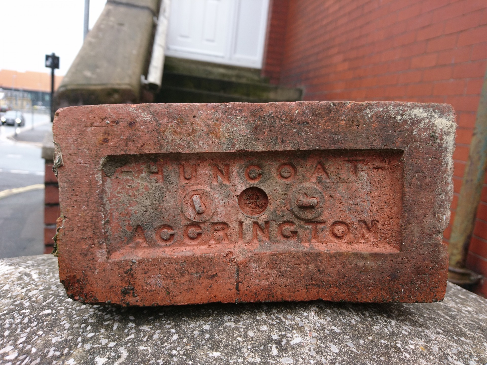
PS. Look what Peter found in the street in Rochdale. I wonder if we walked over the old brickwork site?
Click on this link to see Peter's Pictures.


Sunday June 9th. Compo's Round. 21 miles. Leader: Dave Sheppard.
Ten of us set off at 08:30 in bright sunshine heading for Hepworth and our morning break. Clouds started forming as we passed through Barnside but conditions remained good underfoot. Everyone was in good spirits and keeping up with the leader.
Seven of the group were from Yorkshire, leaving three of us from East Lancs.
As we neared the village of Fulstone the heavens opened with a scramble for the wet gear. Luckily it was short lived and cleared just in time for the lunch stop.
We then moved on to Holmfirth, stopping for photo's of Compo's cafe and Nora Batty`s house. (TVs Last of the Summer Wine).
After a steep climb in warm sun we made our way to Upperthong to take a last break .We finished the day with a last loop of Digley reservoir arriving back at the car park for 16:30.
Total Number on walk - 10
Weather - Heavy Shower, Sunny.
Leader - Dave Sheppard
Wednesday June 5th. The Arndale, T'other way round. 14 miles. Leader: Don Watson.
Sixteen walkers and Maude the dog met at St. John's Parish Church, Silverdale on a day of mixed weather.
I led this walk last year in April and it poured with rain all day and we saw nothing. So I thought we would have a better chance of views in June, which we did, but still suffered some heavy rain showers.
I did the walk the other way round thinking that I knew the route like the back of my hand, but alas, some of the paths confused me in the woods early on in the walk.
We left Silverdale Village and walked across The Lots towards The Cove and then skirted Holgates Caravan Site and through Far Arnside and then the woods to New Barns along the coast.
On leaving New Barns we heard the siren, warning people to clear the sands before the bore arrived. We walked on to Arnside where we sat on the front awaiting the bore which arrived after another siren. Some of the group had never seen it, so it was worth the wait, even though it wasn't at its most spectacular.
From Arnside we crossed the railway line and then walked along the disused railway bed to Storth where we made the ascent to Fairy Steps and had our lunch break. Most of the group climbed the steps, but no fairies were spotted.
From here it was downhill to Hazelslack Farm and across the fields to Arnside Tower, built to stop marauding Scots, I believe.
We then made our way through Holgates Caravan Site and up through Eaves Wood to The Pepper Pot which was built to celebrate Queen Victoria's Silver Jubilee. We had a short sweetie stop to admire the view over Silverdale and Morecambe Bay.
From the Pepper Pot we descended to The Row and made our way back through the fields to St John's and the cars.
Thank you to everyone who made the journey to join me in this wonderful A.O.N.B and I hope you all enjoyed the day out.
Don


