Route summary
This is a summary of the statistics of the main event route.
THE ROUTE IN SUMMARY
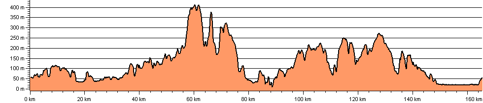
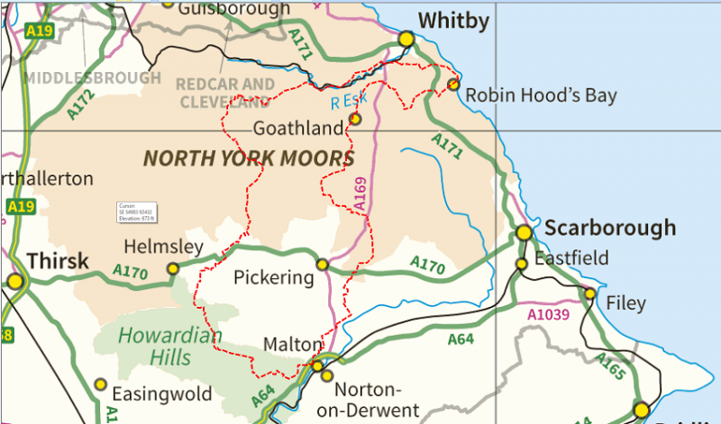
The walk start and finish location will be Malton school although the event start will be 800 yards from the school to aid a smooth send off - once away you will visit the grounds of Castle Howard before climbing up to the Centenary Way and onward to Hovingham. Thereafter the route meanders across the countryside until truly entering the moors of North Yorkshire above the "picture postcard" village of Hutton le Hole - onward to Rosedale and then ascending to the Lion Inn an ideal location for supporters to await you! - onward to Botton village a check point of historic significance and well loved by those who participated in the Cleveland Classic. A special cheese has already been " laid down" in preparation for our event and a complimentary chutney chosen to compliment the other catering on offer here.
Once back out on the moors you will head towards Glaisdale Rigg and thereafter to the coast at Hawsker above Whitby. You will now follow the coast south to picturesque Robin Hoods Bay and then on to breakfast at Fylinghall School.
Once fed and watered you will commence your return to Malton via Goathland - great place for supporters being the location of TV program Heartbeat - both you and they may also see steam trains passing through here or a little later as you cross the rail line at Levisham Station. The route continues through Dalby Forest onward to Thornton le Dale with a fairly flat "run in" to the finish.
AMENDMENTS
Any amendments to the route description will be advised periodically on this site and you are encouraged to revisit the site regularly - we shall seek to limit the amendments to 2-3 releases with the final version being no later than the 20th May - any further amendments thereafter will be advised as you check in at the start of the event.
| Stage | Ascent | Descent | Done | Left | Total Ascent | |||||||||
| No. | Check Point | Grid Ref. | miles | km | feet | m | feet | m | miles | km | miles | km | feet | m |
| Start | Malton | SE 778 721 | 0.0 | 0.0 | 0 | 0 | 0 | 0 | 0.0 | 0.0 | 102.0 | 164.2 | 0 | 0 |
| 1 | Easthorpe | SE 733 7160 | 4.5 | 7.3 | 520 | 158 | 340 | 105 | 4.5 | 7.3 | 97.5 | 157.0 | 520 | 158 |
| 2 | Hovingham | SE 667 756 | 5.7 | 9.2 | 370 | 112 | 610 | 185 | 10.2 | 16.5 | 91.8 | 147.8 | 890 | 270 |
| 3 | Wombleton | SE 670 840 | 8.5 | 13.7 | 430 | 131 | 370 | 113 | 18.7 | 30.2 | 83.3 | 134.1 | 1320 | 401 |
| 4 | Hutton-le-Hole | SE 706 899 | 6.3 | 10.2 | 710 | 215 | 550 | 169 | 25.0 | 40.4 | 77.0 | 123.9 | 2030 | 616 |
| 5 | Rosedale | SE 724 959 | 6.8 | 11.0 | 840 | 255 | 710 | 217 | 31.8 | 51.4 | 70.2 | 112.9 | 2870 | 871 |
| 6 | Botton | NZ 696 041 | 8.0 | 12.9 | 1380 | 420 | 1130 | 345 | 39.8 | 64.3 | 62.2 | 100.0 | 4250 | 1291 |
| 7 | Glaisdale | NZ 775 057 | 6.8 | 10.9 | 1230 | 376 | 1420 | 432 | 46.6 | 75.2 | 55.4 | 89.1 | 5480 | 1667 |
| 8 | Sleights | NZ 867 078 | 7.7 | 12.4 | 750 | 228 | 1160 | 354 | 54.3 | 87.6 | 47.7 | 76.7 | 6230 | 1895 |
| 9 | Hawsker | NZ 925 077 | 4.6 | 7.4 | 580 | 178 | 340 | 104 | 58.9 | 95.0 | 43.1 | 69.3 | 6810 | 2073 |
| 10 | Fyling Hall | NZ 937 043 | 3.0 | 4.8 | 420 | 127 | 320 | 99 | 61.9 | 99.8 | 40.1 | 64.5 | 7230 | 2200 |
| 11 | Littlebeck | NZ 880 050 | 6.1 | 9.8 | 680 | 208 | 850 | 260 | 68.0 | 109.6 | 34.0 | 54.7 | 7910 | 2408 |
| 12 | Goathland | NZ 831 014 | 6.0 | 9.7 | 1200 | 365 | 990 | 302 | 74.0 | 119.3 | 28.0 | 45.0 | 9110 | 2773 |
| 13 | Stape | SE 795 926 | 6.7 | 10.8 | 680 | 207 | 490 | 149 | 80.7 | 130.1 | 21.3 | 34.2 | 9790 | 2980 |
| 14 | Lockton | SE 845 899 | 4.8 | 7.8 | 800 | 245 | 930 | 283 | 85.5 | 137.9 | 16.5 | 26.4 | 10590 | 3225 |
| 15 | Thornton le Dale | SE 833 830 | 5.7 | 9.1 | 500 | 152 | 910 | 276 | 91.2 | 147.0 | 10.8 | 17.3 | 11090 | 3377 |
| 16 | Howebridge Farm | SE 810 764 | 6.3 | 10.1 | 100 | 30 | 170 | 51 | 97.5 | 157.1 | 4.5 | 7.2 | 11190 | 3407 |
| Finish | Malton | SE 779 721 | 4.5 | 7.2 | 180 | 56 | 60 | 18 | 102.0 | 164.2 | 0.0 | 0.0 | 11370 | 3463 |
| Total | 102.0 | 164.2 | 11370 | 3463 | 11350 | 3462 | ||||||||
Route Profile